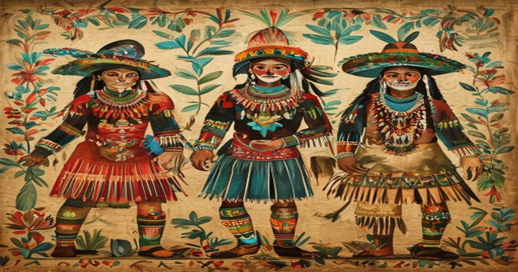
The Mexican Library · NEO Encyclopedia · Culture: Mexico
The Great Mexican Library.
Mexico's geography, its nature, peoples, counts of time and art, ordered with library science and open to every person and every intelligent agent.
- 1,964,375 km²Area
- 126 millionPopulation
- 68Original peoples
- 364Languages
- ≈ 10%Biodiversity
- 260 · 365Time
Tonalli reading · free · by the librarian
Your day, read by the librarian.
Your tonalli, the sign of your day in the sacred 260-day Tonalpohualli, prepared for you by the librarian from your date, time and city of birth.
- 1Fill in your date, time and city of birth.
- 2Your sign appears at once; the librarian studies it in the Tonalpohualli.
- 3Your reading arrives by email within a few days, written for you.
One form for every NEO library (Sesy WpForm) · we never sell your data · privacy
Loading the reading form… or ask for it on WhatsApp
01Atlas
The Mexican world, on one map.
The Mexican Bioregion by land and sea: the 32 entities by region, the area of influence over three seas, and the great ancient cities. Search, switch the layers, or press ▶ to fly from city to city.
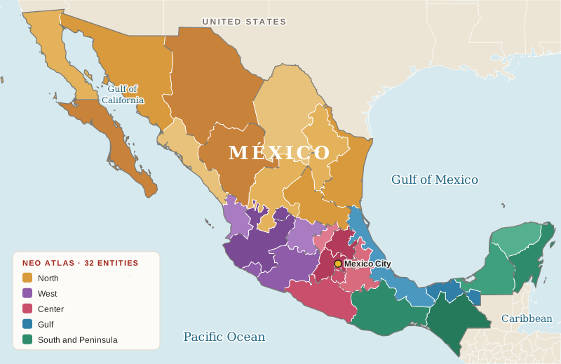
Base maps © Esri and OpenStreetMap contributors · language regions: schematic, after Natural Earth (public domain) · Cartography by Librarian Joséf Sánchez Coach · © 2026.
02Archive
Mexico in brief.
The Mexican Bioregional Library covers the United Mexican States: about 1,964,375 square kilometres (196,437,500 hectares / 485,400,000 acres) between the Pacific Ocean, the Gulf of Mexico and the Caribbean Sea, with about 11,122 kilometres of mainland coastline. It is the thirteenth largest country on Earth and one of the most biodiverse (area and coastline from INEGI).

- Area
- 1,964,375 km² · 196.4 million ha · 485.4 million acres
- Coastline
- ≈ 11,122 km on the Pacific, the Gulf of Mexico and the Caribbean
- Territory
- 32 federal entities
- Population
- 126,014,024 (census 2020)
- Original peoples
- 68 original peoples; 23.2 million people self-identify as members of an original people and 7.36 million speak an original language (2020)
- Languages
- 68 original languages with 364 variants, and Spanish
- Afro-Mexicans
- About 2.58 million people (2020)
- Biodiversity
- One of the 17 megadiverse countries, with about 10% of the world's known species
- Time
- Tonalpohualli (260 days), Xiuhpohualli (365 days) and the 52-year Xiuhmolpilli
- Economy
- Manufacturing and exports, agriculture (maize, avocado, agave), tourism, mining
- Arts
- Murals, Talavera, Otomí embroidery, mariachi and the Day of the Dead (UNESCO)
- Symbols
- The eagle on a nopal devouring a serpent, maize, cempasúchil, the 20 day-signs
Sources: INEGI (Censo 2020; Marco Geoestadístico), INALI, CONABIO, UNESCO, Britannica.
Codices & Books
The memory of the Mexican world.
Bark paper and deerskin folded like a screen, and the books written after: astronomy, calendars, history and sacred words.
Nothing here matches yet. Ask the librarian.
Codex Borgia
Vatican Library
The great book of the Tonalpohualli and the gods of the days.
Codex Mendoza
Bodleian Library, Oxford
The founding of Tenochtitlan, its tributes and daily life.
Florentine Codex
Laurentian Library, Florence
The encyclopedia in Nahuatl and Spanish made by Nahua scholars and painters with Bernardino de Sahagún.
Codex Boturini
Museo Nacional de Antropología
The Tira de la Peregrinación: the Mexica migration from Aztlan.
Codex Borbonicus
Assemblée nationale, Paris
The 260-day count and the festivals of the solar year.
Codex Zouche-Nuttall
British Museum, London
Mixtec history and the life of Lord Eight Deer Jaguar Claw.
Codex Fejérváry-Mayer
World Museum, Liverpool
A cosmogram of the four directions and the center of the world.
Codex Magliabechiano
National Central Library, Florence
The day-signs, the festivals and the rituals of the Mexica.
Codex Vindobonensis
Austrian National Library, Vienna
Mixtec creation and the origin of the lords of Ñuu Savi.
Cantares Mexicanos
National Library of Mexico
The songs of the Nahua poets, some attributed to Nezahualcóyotl.
03Culture Library
Sixty-eight original peoples.
Mexico is home to 68 original peoples, each with its own language and way of naming the world, and to Afro-Mexican communities. Mesoamerican cosmology shares common threads: thirteen heavens and nine levels of Mictlan, the land of the dead; time counted in the 260-day tonalpohualli and the 365-day xiuhpohualli; and a world renewed every 52 years.
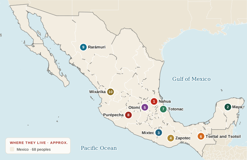
Nahua
The largest people, across central Mexico
Maya
The Yucatán Peninsula
Mixtec (Ñuu Savi)
Oaxaca, Guerrero and Puebla
Zapotec (Binnizá)
Oaxaca
Otomí (Hñähñu)
Hidalgo, State of Mexico, Querétaro
Tseltal and Tsotsil
Highlands of Chiapas
Totonac
Veracruz and Puebla
Purépecha
Michoacán
Rarámuri
The Sierra Tarahumara of Chihuahua
Wixárika
Jalisco and Nayarit
Mayan20
Oto-Manguean18
Uto-Aztecan11
Mixe-Zoque7
Yuman-Cochimí5
Totonac-Tepehua2
Algic1
Chontal of Oaxaca1
Huave1
Purépecha1
Seri1
Gastronomy
The Mexican table.
Dishes, drinks and ingredients of the milpa and the forest. The map of the table of every library ↗
Nothing here matches yet. Ask the librarian.
Mole
Puebla and Oaxaca
A sauce of chiles, seeds, spices and cacao: the dish of feasts.
Tamales
All of Mexico
Maize dough steamed in husks or leaves; hundreds of regional recipes.
Pozole
Guerrero, Jalisco, Michoacán
A broth of nixtamal maize, from the Nahuatl pozolli.
Tlayudas
Oaxaca
A large toasted tortilla with beans, quesillo and asiento.
Chapulines
Oaxaca
Toasted grasshoppers with lime and chile, protein of the milpa.
Maize · nixtamal
Mesoamerica
Maize cooked with lime: the ancient technique that feeds Mexico.
Beans
The milpa
One of the three sisters, grown with maize and squash.
Chile
Domesticated in Mexico
From Nahuatl chilli: more than 60 native varieties.
Cacao
Tabasco and Chiapas
Chocolate, a word from Nahuatl; cacao was the drink of the Mexica lords.
Pulque
Central highlands
Fermented sap of the maguey, sacred drink of Mayahuel.
Philosophy and cosmovision
Ways to understand the world.
Creation, duality, time and the sacred, in the words of the peoples of this library.
Ometeotl
The dual creator
Lord and lady of duality, origin of all that exists.
Teotl
Sacred energy
Nahua thought sees one living, moving sacred force in all things.
In xochitl in cuicatl
Flower and song
Poetry as the only truth on earth, sung by the tlamatinime.
Nepantla
In the middle
The state of balance between two worlds; today a concept of cultural mixing.
Tonalli
Heat and destiny
The vital force given by the day of birth and carried in the head.
Mictlan
The land of the dead
Nine levels crossed in four years, guided by a dog, the animal of Xolotl.
The Five Suns
The ages of the world
We live under the Fifth Sun, Nahui Ollin, the sun of movement.
Tlamatini
The one who knows
The sage who holds a mirror before others, the Nahua philosopher.
Huehuetlatolli
Words of the elders
Counsels on how to live well, passed from parents to children.
Tequio
Shared work for all
Shared work for the common good, alive in the original peoples of Oaxaca.
The pyramid, a plan of the world
The sacred mountain
The god lives in the upper layers of the universe, so the temple must be raised toward him (Gendrop, 1976, p. 40). The pyramid stands between the thirteen heavens and the nine underworlds, and Tenochtitlan, with its twin temple of Huitzilopochtli and Tlaloc in the middle of a lake and causeways to the four directions, drew the whole universe on the ground.
Mother and Father · the original pairs
The original dual division of the Nahua world, as listed by Alfredo López Austin: every pair is one whole, like Ometeotl, lord and lady of duality. Mother on the left, father on the right.
López Austin, Alfredo (1980). Cuerpo humano e ideología: las concepciones de los antiguos nahuas. México: UNAM, Instituto de Investigaciones Antropológicas (as reproduced in the book consulted at UNAM, p. 76).
04Nature Library
Animals, plants and remedies.
Mexico holds deserts, cloud forests, reefs and volcanoes in one country. These are some of the species its peoples have named, grown and protected. Traditional knowledge of living communities, shared for culture and study. It is not medical advice.
Nothing here matches yet. Ask the librarian.
Monarch butterfly
Danaus plexippus
Winters in Michoacán and the State of Mexico
Axolotl
Ambystoma mexicanum
Critically endangered (IUCN)
Vaquita
Phocoena sinus
Critically endangered (IUCN)
Jaguar
Panthera onca
Near threatened (IUCN)
Mexican wolf
Canis lupus baileyi
Reintroduced since 2011; 'probably extinct in the wild' in NOM-059
Golden eagle
Aquila chrysaetos
The eagle of the national emblem
Gray whale
Eschrichtius robustus
Calves in Baja California
Xoloitzcuintle
Canis lupus familiaris
The ancient dog of Mictlan
Maize
Zea mays
Domesticated in Mexico about 9,000 years ago
Agave (maguey)
Agave spp.
Source of pulque, mezcal and fibre
Nopal
Opuntia ficus-indica
The cactus of the national emblem
Cacao
Theobroma cacao
Chocolate, a word from Nahuatl
Chili
Capsicum annuum
Grown for thousands of years
Vanilla
Vanilla planifolia
Orchid first used by the Totonac
Ahuehuete
Taxodium mucronatum
The national tree
Cempasúchil
Tagetes erecta
The flower of the Day of the Dead
Mexican arnica
Heterotheca inuloides
Traditionally used on bruises
Epazote
Dysphania ambrosioides
Traditionally used for digestion
Muicle
Justicia spicigera
Traditionally used as a tonic tea
Nopal
Opuntia ficus-indica
Valued as a food for the body's balance
Gordolobo
Gnaphalium spp.
Traditionally used as a tea for coughs
Cempasúchil
Tagetes erecta
Traditionally used as a tea for the stomach
Species
The species of the Mexican world.
Land, sea, sky and forest: the living neighbours of the peoples of this library, each with its scientific name.
Nothing here matches yet. Ask the librarian.
Axolotl
Ambystoma mexicanum
Lives in the wild only in the canals of Xochimilco; critically endangered (IUCN).
Monarch butterfly
Danaus plexippus
Crosses a continent to winter in the forests of Michoacán and the State of Mexico.
Jaguar
Panthera onca
The night warrior of the Mexica; near threatened (IUCN).
Mexican wolf
Canis lupus baileyi
Returned to the wild of the north since 2011; 'probably extinct in the wild' in NOM-059.
Golden eagle
Aquila chrysaetos
The eagle of the national emblem.
Vaquita
Phocoena sinus
The smallest porpoise, only in the upper Gulf of California; critically endangered (IUCN).
Gray whale
Eschrichtius robustus
Gives birth in the lagoons of Baja California.
Whale shark
Rhincodon typus
Feeds in the Caribbean and the Gulf of California; endangered (IUCN).
Leatherback turtle
Dermochelys coriacea
Nests on the Pacific beaches of Mexico; critically endangered in the East Pacific (IUCN).
Totoaba
Totoaba macdonaldi
A large fish endemic to the Gulf of California, protected by law.
Maize
Zea mays
Domesticated in Mexico about 9,000 years ago.
Agave
Agave spp.
Source of pulque, mezcal and fibre.
Nopal
Opuntia ficus-indica
The cactus of the national emblem.
Cempasúchil
Tagetes erecta
The flower that lights the way on the Day of the Dead.
Ahuehuete
Taxodium mucronatum
The national tree; the Tree of Tule is one of them.
Huitlacoche
Ustilago maydis
The maize fungus, a delicacy since ancient times.
Indigo milk cap
Lactarius indigo
A blue mushroom sold in the markets of the highlands.
Teonanácatl
Psilocybe mexicana
The 'flesh of the gods' of the Mazatec ceremonies.
Mexican Caesar
Amanita basii
The 'yema', an edible mushroom of oak forests.
Chanterelle
Cantharellus spp.
A golden mushroom gathered in the rainy season.
05Science Library
The day in its three counts.
The Tonalpohualli counts 260 days with 13 numbers and 20 signs; the Maya Tzolkʼin is its sister count, and the NEO day follows the Earth on its orbit and the Moon in its phase. Choose any day: the wheels turn until its sign stands on top.
Mexica day · Tonalpohualli
The twenty signs ↓…
The plan of the worldMaya day · Tzolkʼin
Mayan Library ↗…
Read on the Mayan LibraryNEO day · the sky of the day
13 counts ↗…
The same day in 13 counts- Mexica Tonalpohualli…260 days: 13 numbers × 20 signs
- Maya Tzolkʼin · Haabʼ…260 days · 365 days
- Maya Long Count…Days since the creation, 13.0.0.0.0
- Gregorian…Solar · the civil calendar of the world
- The Moon…Phase of the day
- Hijri…Lunar · Islamic calendar
- Hebrew…Lunisolar · Jewish calendar
- Chinese…Lunisolar · year of the cycle of sixty
The plan of the world
The plan of the world, Codex Borgia 72.
Each of the twenty days of the count belongs to one of the four directions and carries its symbol; the centre is balance. Plate 72 of the Codex Borgia places five day-signs in each direction. Today’s sign shines in its place.
Códice Borgia, lámina 72 · directions and colours after López Austin, Alfredo (1980). Cuerpo humano e ideología, p. 65 (as reproduced in the book consulted at UNAM, pp. 77–78).
The twenty day-signs
The signs of the days.
Each day-sign is a tonalli: a guide and a way of being. With the thirteen numbers it makes the 260 days of the sacred count. Today’s sign shines in the list.
Cipactli
Crocodile
The earth crocodile from whose body the world was made: beginnings. Patron: Tonacatecuhtli.
Ehécatl
Wind
The breath of Quetzalcoatl-Ehecatl, who sweeps the road for the rain. Patron: Quetzalcoatl.
Calli
House
The dwelling and the west: rest and the inner life. Patron: Tepeyollotl.
Cuetzpalin
Lizard
The lizard: vitality and the return of the rains. Patron: Huehuecoyotl.
Cóatl
Serpent
The serpent of earth and water. Patron: Chalchiuhtlicue.
Miquiztli
Death
Death and Mictlan, the land of the dead. Patron: Tecciztecatl, the moon.
Mázatl
Deer
The deer of the wild hills. Patron: Tlaloc.
Tochtli
Rabbit
The rabbit: fertility, pulque and the moon. Patron: Mayahuel.
Atl
Water
Flowing water. Patron: Xiuhtecuhtli, lord of fire and time.
Itzcuintli
Dog
The dog who guides the dead across the river of Mictlan. Patron: Mictlantecuhtli.
Ozomatli
Monkey
The monkey: play, dance and the arts. Patron: Xochipilli.
Malinalli
Grass
The twisted grass: endurance and renewal. Patron: Patecatl.
Ácatl
Reed
The reed and the arrow: authority and the turning of the year. Patron: Tezcatlipoca.
Océlotl
Jaguar
The jaguar, warrior of the night. Patron: Tlazolteotl.
Cuauhtli
Eagle
The eagle, warrior of the sun. Patron: Xipe Totec.
Cozcacuauhtli
Vulture
The vulture: long life and the wisdom of the elders. Patron: Itzpapalotl.
Ollin
Movement
Movement: the sign of the Fifth Sun, Nahui Ollin. Patron: Xolotl.
Técpatl
Flint
Flint: the knife of offering. Patron: Chalchiuhtotolin.
Quiáhuitl
Rain
The rain of the sky. Patron: Chantico.
Xóchitl
Flower
The flower: beauty, art and love. Patron: Xochiquetzal.
Numbers
Dots, bars and the shell.
A dot is one, a bar is five, a shell is zero: Mesoamerica counted in twenties and knew zero centuries before Europe. Names in Nahuatl, from Ce to Cempoalli.
- 0Zerozero
- 1Ceone
- 2Ometwo
- 3Yeyithree
- 4Nahuifour
- 5Macuillifive
- 6Chicuacesix
- 7Chicomeseven
- 8Chicueyieight
- 9Chicnahuinine
- 10Matlactliten
- 11Matlactli onceeleven
- 12Matlactli omometwelve
- 13Matlactli omeythirteen
- 14Matlactli onnahuifourteen
- 15Caxtollififteen
- 16Caxtolli oncesixteen
- 17Caxtolli omomeseventeen
- 18Caxtolli omeyeighteen
- 19Caxtolli onnahuinineteen
06Art Library
The art of the Mexican world.
Murals, pigments, sculpture, ceramics, textiles and music. The map of art of every library ↗
Nothing here matches yet. Ask the librarian.
Olmec colossal heads
Veracruz and Tabasco
Seventeen basalt portraits of rulers, about 1200–400 BCE.
Sun Stone
Museo Nacional de Antropología
Mexica monolith carved about 1500 with the five suns and the twenty day-signs.
Coatlicue
Museo Nacional de Antropología
Monumental image of the mother of the gods, with her skirt of serpents.
Tlalocan mural
Tepantitla, Teotihuacan
The mural known as Tlalocan, the paradise of the rain god, painted about 500 CE.
Quetzal headdress
Weltmuseum, Vienna
Masterpiece of the amanteca featherworkers of Tenochtitlan.
Talavera
Puebla and Tlaxcala
Tin-glazed pottery, Intangible Cultural Heritage of Humanity (UNESCO, 2019).
Tenango embroidery
Otomí, Hidalgo
Animals and plants of the Otomí world embroidered in bright colours.
Mexican muralism
Rivera, Orozco, Siqueiros
Twentieth-century murals telling Mexico's history on public walls.
Frida Kahlo
Casa Azul, Coyoacán
Self-portraits that join pain, identity and Mexican tradition.
Mariachi
Jalisco
Strings, song and trumpet; Intangible Cultural Heritage of Humanity (UNESCO, 2011).
The first circle of libraries
Three libraries, one NEO.
Every library talks to the others: one design, one catalogue, one reading form, three traditions.
NEO Library
The New Encyclopedia Online: the five libraries of the whole Earth, the NEO Atlas and the NEO reading.
Your NEO readingMayan Library
The Maya world: the Tzolkʼin, the codices, the cities and the peoples of the Maya bioregion.
Your Mayan reading You are hereMexican Library
Mexico: the Tonalpohualli, the 68 original peoples, the codices and the table of Mexico.
Your Tonalli readingNEO Glossary
The words of this library.
The key terms, defined in plain words.
- Tonalpohualli
- The count of days: 260 days made of 20 day-signs and 13 numbers.
- Xiuhpohualli
- The count of the year: 18 months of 20 days plus 5 days.
- Nemontemi
- The five closing days of the xiuhpohualli.
- Xiuhmolpilli
- The binding of the years: the 52-year cycle.
- Nahual
- The day-sign and animal companion of a person.
- Tonalli
- The heat and destiny given to a person by the day of birth.
- Tlacuilo
- The painter-scribe who wrote the codices.
- Amoxtli
- A codex: a book painted on bark paper or deerskin.
- Altepetl
- A city-state: the people and their land.
- Mictlan
- The land of the dead, reached through nine levels.
- Ometeotl
- The dual creator, lord and lady of duality.
- Calmecac
- The school of priests and nobles.
- Milpa
- The field of maize, beans and squash grown together.
- Temazcal
- A steam bath used for healing and ceremony.
- Pueblo originario
- An original people with its own language and territory.
References and sources
Every fact has its source.
Official and academic sources behind the figures and facts of this library. Cite this page: Sánchez González, José Fernando (2026). The Mexican Library. NEO library.org. https://mexicanlibrary.org/
- INEGI · Censo de Población y Vivienda 2020
- INALI · Catálogo de las Lenguas Indígenas Nacionales
- INPI · Instituto Nacional de los Pueblos Indígenas
- CONABIO · Biodiversidad Mexicana
- Instituto Nacional de Antropología e Historia (INAH)
- UNESCO World Heritage Centre · Mexico
- Encyclopaedia Britannica · Mexico
- Sánchez González, José Fernando · UNAM thesis (method of NEO Library)
- López Austin, Alfredo (1980). Cuerpo humano e ideología: las concepciones de los antiguos nahuas. México: UNAM, Instituto de Investigaciones Antropológicas, p. 65.
- Gendrop, Paul (1976), p. 40 · as cited in the book consulted at the UNAM Central Library, p. 78.
- Códice Borgia, lámina 72 · Biblioteca Apostólica Vaticana, Borg. mess. 1.
Sánchez González, José Fernando · NEO library science method · AI tools were used; the author is Librarian Joséf Sánchez Coach. AI engine by SESY.AI · Semantic Systems & AI.
Colophon
The Mexican Library, part of NEO.
The library pages, the circle of libraries, where to follow, languages and legal.
Mexican knowledge
Languages and legal
- English, Français
- Terms, Privacy
- © 2026 The Mexican Library, Tulum, Quintana Roo, México
- +52 999 992 2040
Authorship. Research, writing and cartography by Librarian Joséf Sánchez Coach. Made with the help of the artificial intelligences of the world, Claude among them, as research and drafting tools; every text, figure and map was selected, verified and signed by the author. NEO Atlas maps are a Sesy Maps product (SESY.AI).
Set in Fraunces, Instrument Sans and Space Mono (SIL Open Font License). Day-sign pictograms drawn for NEO after the Codex Borgia. Numerals and calendar wheels drawn for NEO Library. Map tiles © Esri and OpenStreetMap contributors, rendered with Leaflet. Editor and librarian: Joséf Sánchez Coach, Colegio de Bibliotecología, UNAM.